|
|
|||||||||||||||||
| Point ID: 7220 | Downloads | Plots | Site Data | Code: 12315 |
|
|
|||||||||||||||||
| Download | |
|---|---|
| Site Descriptor Information | Site Time Series Data |
| Link to all available data | |
| View: | Time Series | All |
| Units: | mm |
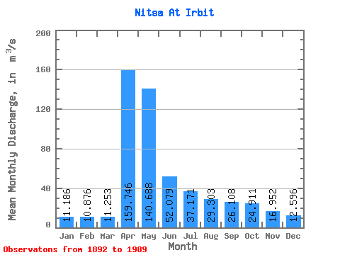
| Statistic | Jan | Feb | Mar | Apr | May | Jun | Jul | Aug | Sep | Oct | Nov | Dec | Annual |
|---|---|---|---|---|---|---|---|---|---|---|---|---|---|
| Mean | 11.19 | 10.88 | 11.25 | 159.75 | 140.69 | 52.08 | 37.17 | 29.30 | 26.11 | 24.91 | 16.95 | 12.60 | 44.29 |
| Standard Deviation | 4.29 | 3.93 | 4.09 | 113.02 | 108.76 | 37.30 | 36.90 | 33.46 | 28.19 | 27.90 | 15.03 | 6.57 | 22.00 |
| Min | 2.50 | 3.43 | 4.05 | 15.50 | 15.10 | 8.20 | 7.95 | 5.79 | 5.42 | 6.19 | 4.69 | 4.36 | 11.53 |
| Max | 24.20 | 20.40 | 22.70 | 488.00 | 529.00 | 195.00 | 211.00 | 202.00 | 171.00 | 166.00 | 111.00 | 39.20 | 105.24 |
| Coefficient of Variation | 0.38 | 0.36 | 0.36 | 0.71 | 0.77 | 0.72 | 0.99 | 1.14 | 1.08 | 1.12 | 0.89 | 0.52 | 0.50 |
 Return to R-Arctic Net Home Page