|
|
|||||||||||||||||
| Point ID: 7215 | Downloads | Plots | Site Data | Code: 12279 |
|
|
|||||||||||||||||
| Download | |
|---|---|
| Site Descriptor Information | Site Time Series Data |
| Link to all available data | |
| View: | Time Series | All |
| Units: | m3/s |
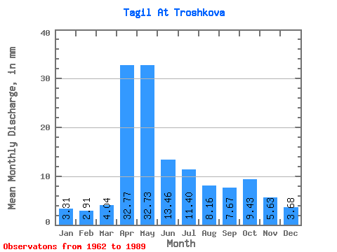
| Statistic | Jan | Feb | Mar | Apr | May | Jun | Jul | Aug | Sep | Oct | Nov | Dec | Annual |
|---|---|---|---|---|---|---|---|---|---|---|---|---|---|
| Mean | 3.31 | 2.93 | 4.04 | 32.77 | 32.73 | 13.46 | 11.40 | 8.16 | 7.67 | 9.43 | 5.63 | 3.68 | 135.01 |
| Standard Deviation | 0.97 | 0.77 | 1.34 | 20.23 | 21.51 | 9.46 | 10.96 | 6.03 | 6.18 | 9.39 | 3.19 | 1.40 | 54.23 |
| Min | 1.82 | 1.71 | 2.05 | 6.74 | 5.34 | 3.93 | 2.89 | 3.38 | 2.85 | 2.66 | 2.20 | 1.92 | 54.14 |
| Max | 5.58 | 4.81 | 7.30 | 74.94 | 89.94 | 48.11 | 41.25 | 28.07 | 23.70 | 42.27 | 15.58 | 6.83 | 225.97 |
| Coefficient of Variation | 0.29 | 0.26 | 0.33 | 0.62 | 0.66 | 0.70 | 0.96 | 0.74 | 0.81 | 0.99 | 0.57 | 0.38 | 0.40 |
 Return to R-Arctic Net Home Page