|
|
|||||||||||||||||
| Point ID: 7215 | Downloads | Plots | Site Data | Code: 12279 |
|
|
|||||||||||||||||
| Download | |
|---|---|
| Site Descriptor Information | Site Time Series Data |
| Link to all available data | |
| View: | Time Series | All |
| Units: | mm |
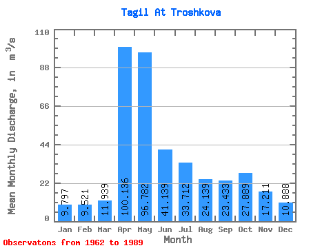
| Statistic | Jan | Feb | Mar | Apr | May | Jun | Jul | Aug | Sep | Oct | Nov | Dec | Annual |
|---|---|---|---|---|---|---|---|---|---|---|---|---|---|
| Mean | 9.80 | 9.52 | 11.94 | 100.14 | 96.78 | 41.14 | 33.71 | 24.14 | 23.43 | 27.89 | 17.21 | 10.89 | 33.88 |
| Standard Deviation | 2.87 | 2.49 | 3.97 | 61.82 | 63.61 | 28.90 | 32.42 | 17.82 | 18.88 | 27.76 | 9.74 | 4.13 | 13.61 |
| Min | 5.38 | 5.54 | 6.06 | 20.60 | 15.80 | 12.00 | 8.56 | 10.00 | 8.72 | 7.88 | 6.73 | 5.67 | 13.59 |
| Max | 16.50 | 15.60 | 21.60 | 229.00 | 266.00 | 147.00 | 122.00 | 83.00 | 72.40 | 125.00 | 47.60 | 20.20 | 56.71 |
| Coefficient of Variation | 0.29 | 0.26 | 0.33 | 0.62 | 0.66 | 0.70 | 0.96 | 0.74 | 0.81 | 0.99 | 0.57 | 0.38 | 0.40 |
 Return to R-Arctic Net Home Page