|
|
|||||||||||||||||
| Point ID: 7211 | Downloads | Plots | Site Data | Code: 12239 |
|
|
|||||||||||||||||
| Download | |
|---|---|
| Site Descriptor Information | Site Time Series Data |
| Link to all available data | |
| View: | Time Series | All |
| Units: | m3/s |
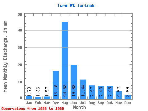
| Statistic | Jan | Feb | Mar | Apr | May | Jun | Jul | Aug | Sep | Oct | Nov | Dec | Annual |
|---|---|---|---|---|---|---|---|---|---|---|---|---|---|
| Mean | 1.78 | 1.38 | 1.57 | 16.18 | 44.81 | 19.83 | 11.44 | 7.97 | 7.43 | 7.48 | 4.57 | 2.59 | 126.44 |
| Standard Deviation | 0.97 | 0.64 | 0.74 | 10.55 | 22.05 | 10.57 | 10.30 | 8.92 | 9.21 | 8.15 | 4.34 | 1.89 | 55.59 |
| Min | 0.41 | 0.35 | 0.48 | 0.95 | 7.24 | 3.74 | 1.93 | 1.45 | 1.32 | 1.15 | 1.02 | 0.82 | 39.93 |
| Max | 4.76 | 3.37 | 3.79 | 49.78 | 110.81 | 47.28 | 38.23 | 39.89 | 51.04 | 36.29 | 20.74 | 9.33 | 265.74 |
| Coefficient of Variation | 0.55 | 0.47 | 0.47 | 0.65 | 0.49 | 0.53 | 0.90 | 1.12 | 1.24 | 1.09 | 0.95 | 0.73 | 0.44 |
 Return to R-Arctic Net Home Page