|
|
|||||||||||||||||
| Point ID: 7211 | Downloads | Plots | Site Data | Code: 12239 |
|
|
|||||||||||||||||
| Download | |
|---|---|
| Site Descriptor Information | Site Time Series Data |
| Link to all available data | |
| View: | Time Series | All |
| Units: | mm |
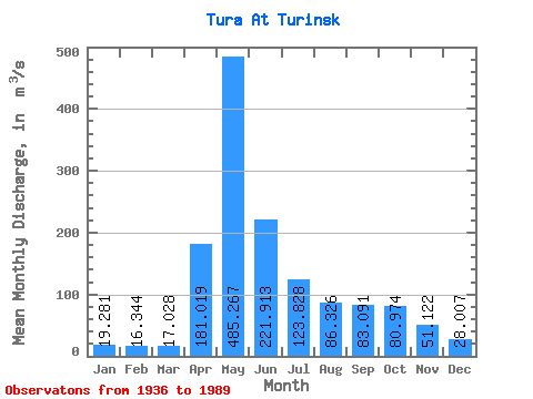
| Statistic | Jan | Feb | Mar | Apr | May | Jun | Jul | Aug | Sep | Oct | Nov | Dec | Annual |
|---|---|---|---|---|---|---|---|---|---|---|---|---|---|
| Mean | 19.28 | 16.34 | 17.03 | 181.02 | 485.27 | 221.91 | 123.83 | 86.33 | 83.09 | 80.97 | 51.12 | 28.01 | 116.18 |
| Standard Deviation | 10.52 | 7.59 | 8.07 | 118.06 | 238.78 | 118.31 | 111.53 | 96.56 | 103.00 | 88.22 | 48.61 | 20.42 | 51.08 |
| Min | 4.45 | 4.13 | 5.18 | 10.60 | 78.40 | 41.80 | 20.90 | 15.70 | 14.80 | 12.50 | 11.40 | 8.89 | 36.69 |
| Max | 51.50 | 40.10 | 41.00 | 557.00 | 1200.00 | 529.00 | 414.00 | 432.00 | 571.00 | 393.00 | 232.00 | 101.00 | 244.18 |
| Coefficient of Variation | 0.55 | 0.47 | 0.47 | 0.65 | 0.49 | 0.53 | 0.90 | 1.12 | 1.24 | 1.09 | 0.95 | 0.73 | 0.44 |
 Return to R-Arctic Net Home Page