|
|
|||||||||||||||||
| Point ID: 7210 | Downloads | Plots | Site Data | Code: 12237 |
|
|
|||||||||||||||||
| Download | |
|---|---|
| Site Descriptor Information | Site Time Series Data |
| Link to all available data | |
| View: | Time Series | All |
| Units: | m3/s |
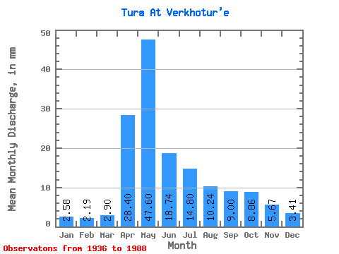
| Statistic | Jan | Feb | Mar | Apr | May | Jun | Jul | Aug | Sep | Oct | Nov | Dec | Annual |
|---|---|---|---|---|---|---|---|---|---|---|---|---|---|
| Mean | 2.58 | 2.21 | 2.90 | 28.40 | 47.59 | 18.74 | 14.79 | 10.24 | 9.00 | 8.86 | 5.67 | 3.41 | 154.91 |
| Standard Deviation | 1.24 | 0.94 | 1.79 | 20.09 | 29.49 | 12.30 | 15.78 | 10.37 | 9.31 | 8.20 | 3.64 | 1.59 | 62.85 |
| Min | 0.99 | 0.80 | 0.72 | 3.02 | 5.05 | 5.39 | 1.76 | 1.38 | 1.29 | 0.86 | 0.47 | 0.69 | 60.67 |
| Max | 5.67 | 4.31 | 11.69 | 81.34 | 127.07 | 69.58 | 72.39 | 52.65 | 47.28 | 35.84 | 17.10 | 7.64 | 296.07 |
| Coefficient of Variation | 0.48 | 0.42 | 0.62 | 0.71 | 0.62 | 0.66 | 1.07 | 1.01 | 1.03 | 0.93 | 0.64 | 0.47 | 0.41 |
 Return to R-Arctic Net Home Page