|
|
|||||||||||||||||
| Point ID: 7210 | Downloads | Plots | Site Data | Code: 12237 |
|
|
|||||||||||||||||
| Download | |
|---|---|
| Site Descriptor Information | Site Time Series Data |
| Link to all available data | |
| View: | Time Series | All |
| Units: | mm |
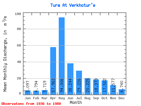
| Statistic | Jan | Feb | Mar | Apr | May | Jun | Jul | Aug | Sep | Oct | Nov | Dec | Annual |
|---|---|---|---|---|---|---|---|---|---|---|---|---|---|
| Mean | 5.10 | 4.79 | 5.72 | 57.96 | 94.01 | 38.24 | 29.23 | 20.23 | 18.37 | 17.50 | 11.58 | 6.74 | 25.97 |
| Standard Deviation | 2.44 | 2.03 | 3.54 | 41.01 | 58.26 | 25.10 | 31.16 | 20.48 | 19.00 | 16.19 | 7.42 | 3.14 | 10.54 |
| Min | 1.95 | 1.74 | 1.42 | 6.16 | 9.98 | 11.00 | 3.47 | 2.73 | 2.63 | 1.69 | 0.96 | 1.37 | 10.17 |
| Max | 11.20 | 9.35 | 23.10 | 166.00 | 251.00 | 142.00 | 143.00 | 104.00 | 96.50 | 70.80 | 34.90 | 15.10 | 49.63 |
| Coefficient of Variation | 0.48 | 0.42 | 0.62 | 0.71 | 0.62 | 0.66 | 1.07 | 1.01 | 1.03 | 0.93 | 0.64 | 0.47 | 0.41 |
 Return to R-Arctic Net Home Page