|
|
|||||||||||||||||
| Point ID: 7199 | Downloads | Plots | Site Data | Code: 12195 |
|
|
|||||||||||||||||
| Download | |
|---|---|
| Site Descriptor Information | Site Time Series Data |
| Link to all available data | |
| View: | Time Series | All |
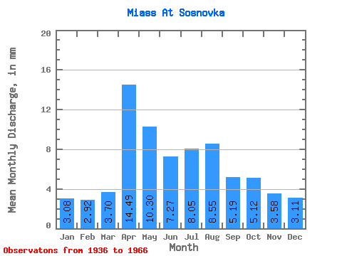
| Units: | m3/s |
| Statistic | Jan | Feb | Mar | Apr | May | Jun | Jul | Aug | Sep | Oct | Nov | Dec | Annual |
|---|---|---|---|---|---|---|---|---|---|---|---|---|---|
| Mean | 3.05 | 2.91 | 3.66 | 14.32 | 10.18 | 7.18 | 7.96 | 8.46 | 5.14 | 5.06 | 3.54 | 3.07 | 74.72 |
| Standard Deviation | 1.57 | 1.42 | 2.09 | 10.96 | 11.71 | 6.25 | 7.07 | 9.75 | 2.81 | 3.04 | 1.75 | 1.49 | 39.53 |
| Min | 0.69 | 0.60 | 0.71 | 3.79 | 2.09 | 1.98 | 2.96 | 2.69 | 2.57 | 1.67 | 0.96 | 0.83 | 29.72 |
| Max | 9.11 | 6.27 | 8.91 | 54.39 | 63.79 | 28.52 | 31.99 | 43.23 | 14.36 | 17.01 | 8.28 | 8.86 | 190.54 |
| Coefficient of Variation | 0.52 | 0.49 | 0.57 | 0.77 | 1.15 | 0.87 | 0.89 | 1.15 | 0.55 | 0.60 | 0.49 | 0.48 | 0.53 |
 Return to R-Arctic Net Home Page