|
|
|||||||||||||||||
| Point ID: 7199 | Downloads | Plots | Site Data | Code: 12195 |
|
|
|||||||||||||||||
| Download | |
|---|---|
| Site Descriptor Information | Site Time Series Data |
| Link to all available data | |
| View: | Time Series | All |
| Units: | mm |
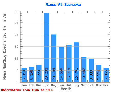
| Statistic | Jan | Feb | Mar | Apr | May | Jun | Jul | Aug | Sep | Oct | Nov | Dec | Annual |
|---|---|---|---|---|---|---|---|---|---|---|---|---|---|
| Mean | 6.02 | 6.30 | 7.22 | 29.23 | 20.10 | 14.66 | 15.72 | 16.70 | 10.48 | 9.99 | 7.22 | 6.07 | 12.52 |
| Standard Deviation | 3.10 | 3.08 | 4.12 | 22.36 | 23.12 | 12.75 | 13.97 | 19.26 | 5.74 | 6.00 | 3.57 | 2.94 | 6.63 |
| Min | 1.36 | 1.30 | 1.41 | 7.74 | 4.13 | 4.04 | 5.84 | 5.31 | 5.24 | 3.30 | 1.96 | 1.64 | 4.98 |
| Max | 18.00 | 13.60 | 17.60 | 111.00 | 126.00 | 58.20 | 63.20 | 85.40 | 29.30 | 33.60 | 16.90 | 17.50 | 31.94 |
| Coefficient of Variation | 0.52 | 0.49 | 0.57 | 0.77 | 1.15 | 0.87 | 0.89 | 1.15 | 0.55 | 0.60 | 0.49 | 0.48 | 0.53 |
 Return to R-Arctic Net Home Page