|
|
|||||||||||||||||
| Point ID: 7176 | Downloads | Plots | Site Data | Code: 12101 |
|
|
|||||||||||||||||
| Download | |
|---|---|
| Site Descriptor Information | Site Time Series Data |
| Link to all available data | |
| View: | Time Series | All |
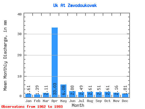
| Units: | m3/s |
| Statistic | Jan | Feb | Mar | Apr | May | Jun | Jul | Aug | Sep | Oct | Nov | Dec | Annual |
|---|---|---|---|---|---|---|---|---|---|---|---|---|---|
| Mean | 1.61 | 1.41 | 2.11 | 33.03 | 6.07 | 2.88 | 2.49 | 2.60 | 2.51 | 2.61 | 2.16 | 1.81 | 62.84 |
| Standard Deviation | 0.63 | 0.59 | 1.14 | 23.00 | 3.21 | 1.63 | 0.80 | 1.03 | 0.76 | 0.86 | 0.63 | 0.47 | 27.56 |
| Min | 0.50 | 0.08 | 0.28 | 4.07 | 2.37 | 1.30 | 0.99 | 1.14 | 1.39 | 1.37 | 0.93 | 0.88 | 32.70 |
| Max | 3.36 | 2.61 | 5.72 | 86.49 | 15.51 | 10.52 | 5.02 | 5.43 | 4.04 | 5.14 | 4.10 | 2.63 | 123.96 |
| Coefficient of Variation | 0.39 | 0.42 | 0.54 | 0.70 | 0.53 | 0.56 | 0.32 | 0.40 | 0.30 | 0.33 | 0.29 | 0.26 | 0.44 |
 Return to R-Arctic Net Home Page