|
|
|||||||||||||||||
| Point ID: 7176 | Downloads | Plots | Site Data | Code: 12101 |
|
|
|||||||||||||||||
| Download | |
|---|---|
| Site Descriptor Information | Site Time Series Data |
| Link to all available data | |
| View: | Time Series | All |
| Units: | mm |
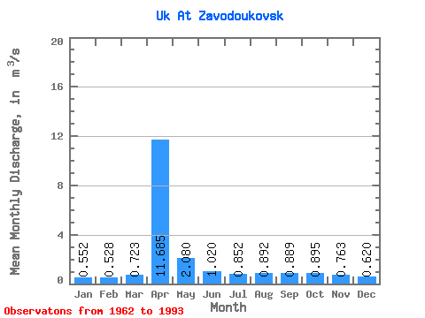
| Statistic | Jan | Feb | Mar | Apr | May | Jun | Jul | Aug | Sep | Oct | Nov | Dec | Annual |
|---|---|---|---|---|---|---|---|---|---|---|---|---|---|
| Mean | 0.55 | 0.53 | 0.72 | 11.69 | 2.08 | 1.02 | 0.85 | 0.89 | 0.89 | 0.90 | 0.76 | 0.62 | 1.83 |
| Standard Deviation | 0.21 | 0.22 | 0.39 | 8.14 | 1.10 | 0.58 | 0.27 | 0.35 | 0.27 | 0.29 | 0.22 | 0.16 | 0.80 |
| Min | 0.17 | 0.03 | 0.10 | 1.44 | 0.81 | 0.46 | 0.34 | 0.39 | 0.49 | 0.47 | 0.33 | 0.30 | 0.95 |
| Max | 1.15 | 0.98 | 1.96 | 30.60 | 5.31 | 3.72 | 1.72 | 1.86 | 1.43 | 1.76 | 1.45 | 0.90 | 3.60 |
| Coefficient of Variation | 0.39 | 0.42 | 0.54 | 0.70 | 0.53 | 0.56 | 0.32 | 0.40 | 0.30 | 0.33 | 0.29 | 0.26 | 0.44 |
 Return to R-Arctic Net Home Page