|
|
|||||||||||||||||
| Point ID: 7174 | Downloads | Plots | Site Data | Code: 12098 |
|
|
|||||||||||||||||
| Download | |
|---|---|
| Site Descriptor Information | Site Time Series Data |
| Link to all available data | |
| View: | Time Series | All |
| Units: | m3/s |
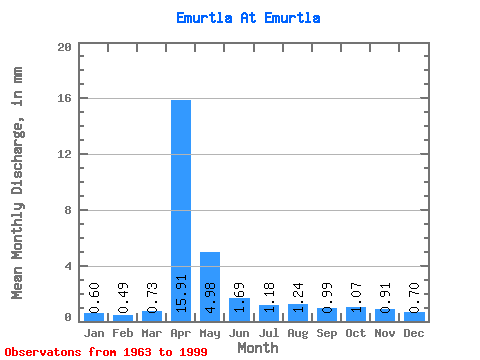
| Statistic | Jan | Feb | Mar | Apr | May | Jun | Jul | Aug | Sep | Oct | Nov | Dec | Annual |
|---|---|---|---|---|---|---|---|---|---|---|---|---|---|
| Mean | 0.60 | 0.50 | 0.73 | 15.91 | 4.98 | 1.69 | 1.18 | 1.24 | 0.99 | 1.07 | 0.92 | 0.70 | 30.53 |
| Standard Deviation | 0.19 | 0.17 | 0.53 | 12.83 | 6.26 | 1.23 | 0.65 | 0.98 | 0.42 | 0.50 | 0.31 | 0.20 | 20.28 |
| Min | 0.15 | 0.01 | 0.14 | 1.66 | 0.93 | 0.48 | 0.51 | 0.54 | 0.51 | 0.53 | 0.33 | 0.23 | 8.00 |
| Max | 0.92 | 0.75 | 3.51 | 52.96 | 36.34 | 6.73 | 3.09 | 6.14 | 2.16 | 3.13 | 1.87 | 1.06 | 101.48 |
| Coefficient of Variation | 0.32 | 0.33 | 0.73 | 0.81 | 1.26 | 0.72 | 0.56 | 0.79 | 0.42 | 0.47 | 0.33 | 0.29 | 0.66 |
 Return to R-Arctic Net Home Page