|
|
|||||||||||||||||
| Point ID: 7174 | Downloads | Plots | Site Data | Code: 12098 |
|
|
|||||||||||||||||
| Download | |
|---|---|
| Site Descriptor Information | Site Time Series Data |
| Link to all available data | |
| View: | Time Series | All |
| Units: | mm |
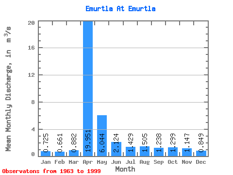
| Statistic | Jan | Feb | Mar | Apr | May | Jun | Jul | Aug | Sep | Oct | Nov | Dec | Annual |
|---|---|---|---|---|---|---|---|---|---|---|---|---|---|
| Mean | 0.72 | 0.66 | 0.88 | 19.95 | 6.04 | 2.12 | 1.43 | 1.50 | 1.24 | 1.30 | 1.15 | 0.85 | 3.14 |
| Standard Deviation | 0.23 | 0.22 | 0.65 | 16.09 | 7.59 | 1.54 | 0.79 | 1.19 | 0.53 | 0.61 | 0.38 | 0.24 | 2.09 |
| Min | 0.18 | 0.01 | 0.17 | 2.08 | 1.13 | 0.60 | 0.62 | 0.65 | 0.64 | 0.64 | 0.41 | 0.28 | 0.82 |
| Max | 1.12 | 1.00 | 4.26 | 66.40 | 44.10 | 8.44 | 3.75 | 7.45 | 2.71 | 3.80 | 2.35 | 1.29 | 10.45 |
| Coefficient of Variation | 0.32 | 0.33 | 0.73 | 0.81 | 1.26 | 0.72 | 0.56 | 0.79 | 0.42 | 0.47 | 0.33 | 0.29 | 0.66 |
 Return to R-Arctic Net Home Page