|
|
|||||||||||||||||
| Point ID: 7170 | Downloads | Plots | Site Data | Code: 12072 |
|
|
|||||||||||||||||
| Download | |
|---|---|
| Site Descriptor Information | Site Time Series Data |
| Link to all available data | |
| View: | Time Series | All |
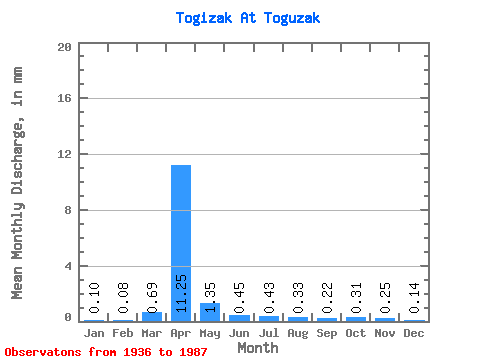
| Units: | m3/s |
| Statistic | Jan | Feb | Mar | Apr | May | Jun | Jul | Aug | Sep | Oct | Nov | Dec | Annual |
|---|---|---|---|---|---|---|---|---|---|---|---|---|---|
| Mean | 0.08 | 0.06 | 0.51 | 8.43 | 1.01 | 0.34 | 0.32 | 0.25 | 0.17 | 0.23 | 0.19 | 0.10 | 14.54 |
| Standard Deviation | 0.07 | 0.05 | 0.94 | 8.72 | 1.28 | 0.29 | 0.54 | 0.48 | 0.15 | 0.20 | 0.14 | 0.09 | 11.78 |
| Min | 0.00 | 0.00 | 0.00 | 0.55 | 0.11 | 0.02 | 0.01 | 0.01 | 0.01 | 0.01 | 0.00 | 0.00 | 1.03 |
| Max | 0.34 | 0.22 | 3.90 | 34.80 | 7.66 | 1.64 | 3.63 | 3.25 | 0.81 | 1.11 | 0.80 | 0.44 | 42.49 |
| Coefficient of Variation | 0.91 | 0.89 | 1.83 | 1.03 | 1.27 | 0.86 | 1.68 | 1.92 | 0.92 | 0.87 | 0.74 | 0.84 | 0.81 |
 Return to R-Arctic Net Home Page