|
|
|||||||||||||||||
| Point ID: 7170 | Downloads | Plots | Site Data | Code: 12072 |
|
|
|||||||||||||||||
| Download | |
|---|---|
| Site Descriptor Information | Site Time Series Data |
| Link to all available data | |
| View: | Time Series | All |
| Units: | mm |
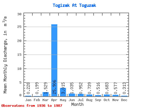
| Statistic | Jan | Feb | Mar | Apr | May | Jun | Jul | Aug | Sep | Oct | Nov | Dec | Annual |
|---|---|---|---|---|---|---|---|---|---|---|---|---|---|
| Mean | 0.23 | 0.20 | 1.53 | 25.91 | 3.02 | 1.03 | 0.95 | 0.74 | 0.52 | 0.68 | 0.58 | 0.31 | 3.67 |
| Standard Deviation | 0.21 | 0.18 | 2.80 | 26.82 | 3.82 | 0.89 | 1.60 | 1.42 | 0.47 | 0.60 | 0.43 | 0.26 | 2.98 |
| Min | 0.00 | 0.00 | 0.00 | 1.70 | 0.34 | 0.07 | 0.01 | 0.02 | 0.04 | 0.04 | 0.00 | 0.00 | 0.26 |
| Max | 1.00 | 0.73 | 11.60 | 107.00 | 22.80 | 5.03 | 10.80 | 9.66 | 2.50 | 3.31 | 2.45 | 1.31 | 10.73 |
| Coefficient of Variation | 0.91 | 0.89 | 1.83 | 1.03 | 1.27 | 0.86 | 1.68 | 1.92 | 0.92 | 0.87 | 0.74 | 0.84 | 0.81 |
 Return to R-Arctic Net Home Page