|
|
|||||||||||||||||
| Point ID: 7160 | Downloads | Plots | Site Data | Code: 12035 |
|
|
|||||||||||||||||
| Download | |
|---|---|
| Site Descriptor Information | Site Time Series Data |
| Link to all available data | |
| View: | Time Series | All |
| Units: | m3/s |
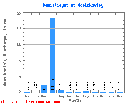
| Statistic | Jan | Feb | Mar | Apr | May | Jun | Jul | Aug | Sep | Oct | Nov | Dec | Annual |
|---|---|---|---|---|---|---|---|---|---|---|---|---|---|
| Mean | 0.08 | 0.04 | 1.89 | 18.56 | 0.64 | 0.26 | 0.33 | 0.36 | 0.20 | 0.32 | 0.24 | 0.16 | 20.59 |
| Standard Deviation | 0.07 | 0.05 | 4.07 | 18.87 | 0.55 | 0.20 | 0.64 | 0.63 | 0.14 | 0.43 | 0.15 | 0.13 | 19.53 |
| Min | 0.00 | 0.00 | 0.00 | 1.08 | 0.01 | 0.00 | 0.00 | 0.00 | 0.00 | 0.00 | 0.00 | 0.00 | 7.69 |
| Max | 0.23 | 0.12 | 16.34 | 67.22 | 2.06 | 0.61 | 3.04 | 2.79 | 0.45 | 2.21 | 0.47 | 0.43 | 54.87 |
| Coefficient of Variation | 0.90 | 1.34 | 2.15 | 1.02 | 0.86 | 0.79 | 1.91 | 1.73 | 0.73 | 1.36 | 0.60 | 0.80 | 0.95 |
 Return to R-Arctic Net Home Page