|
|
|||||||||||||||||
| Point ID: 7160 | Downloads | Plots | Site Data | Code: 12035 |
|
|
|||||||||||||||||
| Download | |
|---|---|
| Site Descriptor Information | Site Time Series Data |
| Link to all available data | |
| View: | Time Series | All |
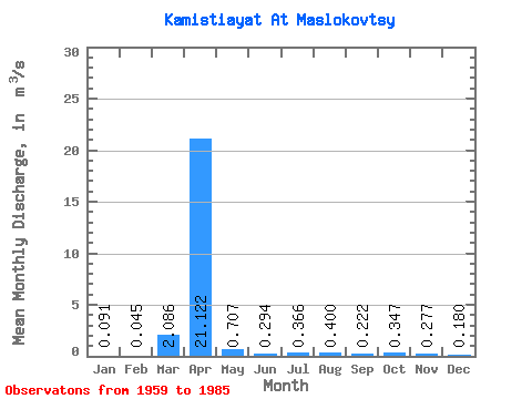
| Units: | mm |
| Statistic | Jan | Feb | Mar | Apr | May | Jun | Jul | Aug | Sep | Oct | Nov | Dec | Annual |
|---|---|---|---|---|---|---|---|---|---|---|---|---|---|
| Mean | 0.09 | 0.04 | 2.09 | 21.12 | 0.71 | 0.29 | 0.37 | 0.40 | 0.22 | 0.35 | 0.28 | 0.18 | 1.92 |
| Standard Deviation | 0.08 | 0.06 | 4.48 | 21.48 | 0.61 | 0.23 | 0.70 | 0.69 | 0.16 | 0.47 | 0.17 | 0.14 | 1.82 |
| Min | 0.00 | 0.00 | 0.00 | 1.23 | 0.01 | 0.00 | 0.00 | 0.00 | 0.00 | 0.00 | 0.00 | 0.00 | 0.72 |
| Max | 0.25 | 0.15 | 18.00 | 76.50 | 2.27 | 0.70 | 3.35 | 3.07 | 0.51 | 2.43 | 0.53 | 0.47 | 5.13 |
| Coefficient of Variation | 0.90 | 1.34 | 2.15 | 1.02 | 0.86 | 0.79 | 1.91 | 1.73 | 0.73 | 1.36 | 0.60 | 0.80 | 0.95 |
 Return to R-Arctic Net Home Page