|
|
|||||||||||||||||
| Point ID: 7156 | Downloads | Plots | Site Data | Code: 12023 |
|
|
|||||||||||||||||
| Download | |
|---|---|
| Site Descriptor Information | Site Time Series Data |
| Link to all available data | |
| View: | Time Series | All |
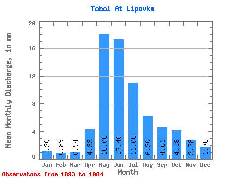
| Units: | m3/s |
| Statistic | Jan | Feb | Mar | Apr | May | Jun | Jul | Aug | Sep | Oct | Nov | Dec | Annual |
|---|---|---|---|---|---|---|---|---|---|---|---|---|---|
| Mean | 1.02 | 0.76 | 0.80 | 3.68 | 15.34 | 14.77 | 9.40 | 5.26 | 3.91 | 3.55 | 2.36 | 1.51 | 61.15 |
| Standard Deviation | 0.46 | 0.30 | 0.28 | 3.17 | 6.06 | 6.78 | 5.27 | 3.59 | 2.94 | 2.74 | 1.53 | 0.75 | 22.88 |
| Min | 0.36 | 0.30 | 0.27 | 0.51 | 4.78 | 3.53 | 1.40 | 1.09 | 0.98 | 0.74 | 0.42 | 0.46 | 25.41 |
| Max | 2.30 | 1.72 | 1.59 | 23.35 | 34.38 | 34.99 | 27.22 | 16.27 | 18.81 | 21.27 | 10.79 | 3.81 | 130.81 |
| Coefficient of Variation | 0.45 | 0.40 | 0.35 | 0.86 | 0.40 | 0.46 | 0.56 | 0.68 | 0.75 | 0.77 | 0.65 | 0.50 | 0.37 |
 Return to R-Arctic Net Home Page