|
|
|||||||||||||||||
| Point ID: 7156 | Downloads | Plots | Site Data | Code: 12023 |
|
|
|||||||||||||||||
| Download | |
|---|---|
| Site Descriptor Information | Site Time Series Data |
| Link to all available data | |
| View: | Time Series | All |
| Units: | mm |
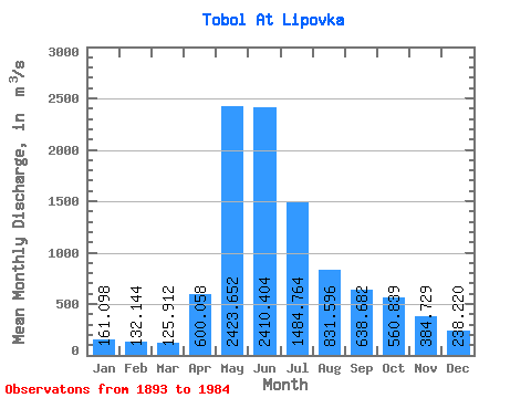
| Statistic | Jan | Feb | Mar | Apr | May | Jun | Jul | Aug | Sep | Oct | Nov | Dec | Annual |
|---|---|---|---|---|---|---|---|---|---|---|---|---|---|
| Mean | 161.10 | 132.14 | 125.91 | 600.06 | 2423.65 | 2410.40 | 1484.76 | 831.60 | 638.68 | 560.84 | 384.73 | 238.22 | 819.65 |
| Standard Deviation | 72.92 | 52.16 | 44.73 | 517.91 | 957.45 | 1106.71 | 831.97 | 566.50 | 479.85 | 432.35 | 250.33 | 118.23 | 306.63 |
| Min | 56.80 | 51.80 | 42.60 | 82.90 | 755.00 | 576.00 | 221.00 | 172.00 | 160.00 | 117.00 | 69.30 | 71.90 | 340.50 |
| Max | 363.00 | 298.00 | 251.00 | 3810.00 | 5430.00 | 5710.00 | 4300.00 | 2570.00 | 3070.00 | 3360.00 | 1760.00 | 601.00 | 1753.25 |
| Coefficient of Variation | 0.45 | 0.40 | 0.35 | 0.86 | 0.40 | 0.46 | 0.56 | 0.68 | 0.75 | 0.77 | 0.65 | 0.50 | 0.37 |
 Return to R-Arctic Net Home Page