|
|
|||||||||||||||||
| Point ID: 7135 | Downloads | Plots | Site Data | Code: 11620 |
|
|
|||||||||||||||||
| Download | |
|---|---|
| Site Descriptor Information | Site Time Series Data |
| Link to all available data | |
| View: | Time Series | All |
| Units: | m3/s |
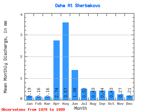
| Statistic | Jan | Feb | Mar | Apr | May | Jun | Jul | Aug | Sep | Oct | Nov | Dec | Annual |
|---|---|---|---|---|---|---|---|---|---|---|---|---|---|
| Mean | 0.19 | 0.16 | 0.15 | 2.74 | 3.57 | 1.38 | 0.53 | 0.43 | 0.44 | 0.43 | 0.27 | 0.21 | 10.41 |
| Standard Deviation | 0.10 | 0.10 | 0.08 | 1.96 | 3.23 | 1.11 | 0.45 | 0.37 | 0.47 | 0.49 | 0.23 | 0.13 | 6.87 |
| Min | 0.08 | 0.07 | 0.08 | 0.23 | 0.28 | 0.14 | 0.06 | 0.05 | 0.02 | 0.02 | 0.07 | 0.08 | 2.65 |
| Max | 0.51 | 0.49 | 0.43 | 6.57 | 13.53 | 4.18 | 1.54 | 1.36 | 2.02 | 2.32 | 1.15 | 0.63 | 22.32 |
| Coefficient of Variation | 0.55 | 0.61 | 0.49 | 0.71 | 0.90 | 0.81 | 0.85 | 0.87 | 1.08 | 1.15 | 0.84 | 0.63 | 0.66 |
 Return to R-Arctic Net Home Page