|
|
|||||||||||||||||
| Point ID: 7135 | Downloads | Plots | Site Data | Code: 11620 |
|
|
|||||||||||||||||
| Download | |
|---|---|
| Site Descriptor Information | Site Time Series Data |
| Link to all available data | |
| View: | Time Series | All |
| Units: | mm |
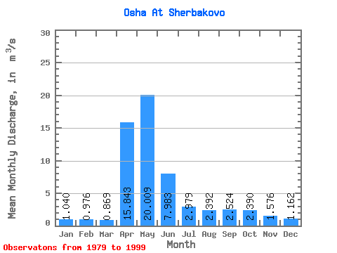
| Statistic | Jan | Feb | Mar | Apr | May | Jun | Jul | Aug | Sep | Oct | Nov | Dec | Annual |
|---|---|---|---|---|---|---|---|---|---|---|---|---|---|
| Mean | 1.04 | 0.98 | 0.87 | 15.84 | 20.01 | 7.98 | 2.98 | 2.39 | 2.52 | 2.39 | 1.58 | 1.16 | 4.95 |
| Standard Deviation | 0.57 | 0.59 | 0.43 | 11.32 | 18.07 | 6.43 | 2.52 | 2.07 | 2.74 | 2.74 | 1.33 | 0.74 | 3.27 |
| Min | 0.46 | 0.43 | 0.45 | 1.34 | 1.54 | 0.79 | 0.32 | 0.28 | 0.13 | 0.10 | 0.39 | 0.45 | 1.26 |
| Max | 2.85 | 3.01 | 2.40 | 38.00 | 75.80 | 24.20 | 8.61 | 7.63 | 11.70 | 13.00 | 6.64 | 3.53 | 10.61 |
| Coefficient of Variation | 0.55 | 0.61 | 0.49 | 0.71 | 0.90 | 0.81 | 0.85 | 0.87 | 1.08 | 1.15 | 0.84 | 0.63 | 0.66 |
 Return to R-Arctic Net Home Page