|
|
|||||||||||||||||
| Point ID: 7127 | Downloads | Plots | Site Data | Code: 11592 |
|
|
|||||||||||||||||
| Download | |
|---|---|
| Site Descriptor Information | Site Time Series Data |
| Link to all available data | |
| View: | Time Series | All |
| Units: | m3/s |
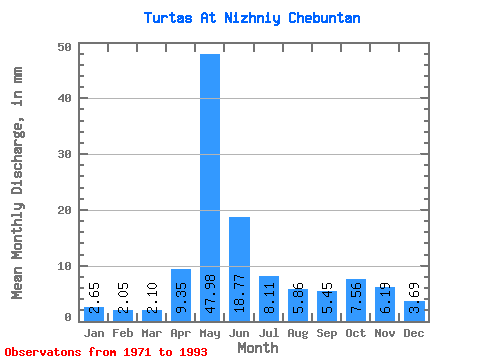
| Statistic | Jan | Feb | Mar | Apr | May | Jun | Jul | Aug | Sep | Oct | Nov | Dec | Annual |
|---|---|---|---|---|---|---|---|---|---|---|---|---|---|
| Mean | 2.65 | 2.07 | 2.10 | 9.35 | 47.97 | 18.77 | 8.11 | 5.86 | 5.45 | 7.56 | 6.19 | 3.69 | 138.92 |
| Standard Deviation | 0.69 | 0.35 | 0.28 | 8.39 | 33.62 | 14.57 | 7.59 | 6.86 | 4.00 | 4.95 | 4.63 | 1.57 | 51.77 |
| Min | 1.86 | 1.46 | 1.60 | 1.99 | 0.01 | 0.06 | 0.03 | 0.01 | 0.01 | 2.40 | 0.07 | 2.10 | 80.85 |
| Max | 4.41 | 2.74 | 2.46 | 32.24 | 101.53 | 57.98 | 26.67 | 29.28 | 15.47 | 19.15 | 17.08 | 8.00 | 271.58 |
| Coefficient of Variation | 0.26 | 0.17 | 0.13 | 0.90 | 0.70 | 0.78 | 0.94 | 1.17 | 0.73 | 0.66 | 0.75 | 0.42 | 0.37 |
 Return to R-Arctic Net Home Page