|
|
|||||||||||||||||
| Point ID: 7127 | Downloads | Plots | Site Data | Code: 11592 |
|
|
|||||||||||||||||
| Download | |
|---|---|
| Site Descriptor Information | Site Time Series Data |
| Link to all available data | |
| View: | Time Series | All |
| Units: | mm |
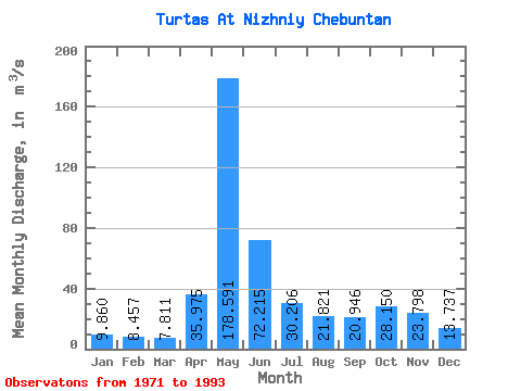
| Statistic | Jan | Feb | Mar | Apr | May | Jun | Jul | Aug | Sep | Oct | Nov | Dec | Annual |
|---|---|---|---|---|---|---|---|---|---|---|---|---|---|
| Mean | 9.86 | 8.46 | 7.81 | 35.98 | 178.59 | 72.22 | 30.21 | 21.82 | 20.95 | 28.15 | 23.80 | 13.74 | 43.89 |
| Standard Deviation | 2.56 | 1.42 | 1.04 | 32.29 | 125.17 | 56.03 | 28.25 | 25.53 | 15.37 | 18.43 | 17.80 | 5.84 | 16.36 |
| Min | 6.91 | 5.97 | 5.97 | 7.66 | 0.04 | 0.23 | 0.11 | 0.02 | 0.04 | 8.93 | 0.27 | 7.83 | 25.54 |
| Max | 16.40 | 11.20 | 9.15 | 124.00 | 378.00 | 223.00 | 99.30 | 109.00 | 59.50 | 71.30 | 65.70 | 29.80 | 85.79 |
| Coefficient of Variation | 0.26 | 0.17 | 0.13 | 0.90 | 0.70 | 0.78 | 0.94 | 1.17 | 0.73 | 0.66 | 0.75 | 0.42 | 0.37 |
 Return to R-Arctic Net Home Page