|
|
|||||||||||||||||
| Point ID: 7104 | Downloads | Plots | Site Data | Code: 11544 |
|
|
|||||||||||||||||
| Download | |
|---|---|
| Site Descriptor Information | Site Time Series Data |
| Link to all available data | |
| View: | Time Series | All |
| Units: | m3/s |
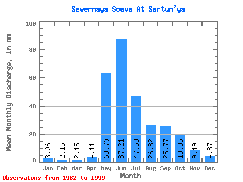
| Statistic | Jan | Feb | Mar | Apr | May | Jun | Jul | Aug | Sep | Oct | Nov | Dec | Annual |
|---|---|---|---|---|---|---|---|---|---|---|---|---|---|
| Mean | 3.06 | 2.17 | 2.15 | 4.11 | 63.69 | 87.21 | 47.53 | 26.82 | 25.77 | 19.35 | 9.19 | 4.87 | 295.75 |
| Standard Deviation | 0.84 | 0.60 | 0.52 | 3.85 | 26.91 | 35.31 | 28.06 | 17.00 | 12.62 | 8.67 | 3.41 | 1.45 | 73.11 |
| Min | 1.19 | 1.07 | 1.01 | 1.28 | 5.15 | 8.03 | 11.55 | 7.05 | 9.00 | 5.89 | 3.46 | 1.85 | 114.14 |
| Max | 5.00 | 3.46 | 3.21 | 17.67 | 109.29 | 154.17 | 120.53 | 77.90 | 51.02 | 38.76 | 17.07 | 8.06 | 423.40 |
| Coefficient of Variation | 0.28 | 0.28 | 0.24 | 0.94 | 0.42 | 0.41 | 0.59 | 0.63 | 0.49 | 0.45 | 0.37 | 0.30 | 0.25 |
 Return to R-Arctic Net Home Page