|
|
|||||||||||||||||
| Point ID: 7104 | Downloads | Plots | Site Data | Code: 11544 |
|
|
|||||||||||||||||
| Download | |
|---|---|
| Site Descriptor Information | Site Time Series Data |
| Link to all available data | |
| View: | Time Series | All |
| Units: | mm |
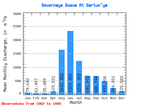
| Statistic | Jan | Feb | Mar | Apr | May | Jun | Jul | Aug | Sep | Oct | Nov | Dec | Annual |
|---|---|---|---|---|---|---|---|---|---|---|---|---|---|
| Mean | 79.04 | 61.50 | 55.49 | 109.53 | 1643.35 | 2324.85 | 1226.35 | 691.97 | 686.94 | 499.31 | 244.93 | 125.58 | 647.53 |
| Standard Deviation | 21.74 | 16.92 | 13.42 | 102.53 | 694.43 | 941.32 | 724.03 | 438.65 | 336.58 | 223.64 | 90.89 | 37.34 | 160.08 |
| Min | 30.70 | 30.30 | 26.20 | 34.10 | 133.00 | 214.00 | 298.00 | 182.00 | 240.00 | 152.00 | 92.20 | 47.80 | 249.90 |
| Max | 129.00 | 98.00 | 82.70 | 471.00 | 2820.00 | 4110.00 | 3110.00 | 2010.00 | 1360.00 | 1000.00 | 455.00 | 208.00 | 927.02 |
| Coefficient of Variation | 0.28 | 0.28 | 0.24 | 0.94 | 0.42 | 0.41 | 0.59 | 0.63 | 0.49 | 0.45 | 0.37 | 0.30 | 0.25 |
 Return to R-Arctic Net Home Page