|
|
|||||||||||||||||
| Point ID: 7090 | Downloads | Plots | Site Data | Code: 11520 |
|
|
|||||||||||||||||
| Download | |
|---|---|
| Site Descriptor Information | Site Time Series Data |
| Link to all available data | |
| View: | Time Series | All |
| Units: | m3/s |
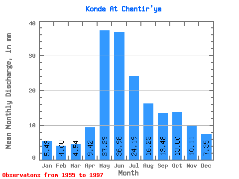
| Statistic | Jan | Feb | Mar | Apr | May | Jun | Jul | Aug | Sep | Oct | Nov | Dec | Annual |
|---|---|---|---|---|---|---|---|---|---|---|---|---|---|
| Mean | 5.43 | 4.12 | 4.54 | 9.42 | 37.28 | 36.98 | 24.18 | 16.23 | 13.48 | 13.79 | 10.11 | 7.35 | 182.06 |
| Standard Deviation | 2.17 | 0.92 | 0.67 | 4.16 | 16.27 | 13.63 | 9.49 | 7.83 | 7.10 | 7.39 | 5.45 | 3.84 | 50.36 |
| Min | 3.12 | 2.70 | 3.41 | 4.33 | 4.70 | 13.84 | 7.32 | 5.09 | 5.72 | 4.24 | 3.21 | 2.97 | 91.65 |
| Max | 11.68 | 6.85 | 6.84 | 24.80 | 77.45 | 69.74 | 55.29 | 35.45 | 30.58 | 33.72 | 24.99 | 18.65 | 297.66 |
| Coefficient of Variation | 0.40 | 0.22 | 0.15 | 0.44 | 0.44 | 0.37 | 0.39 | 0.48 | 0.53 | 0.54 | 0.54 | 0.52 | 0.28 |
 Return to R-Arctic Net Home Page