|
|
|||||||||||||||||
| Point ID: 7090 | Downloads | Plots | Site Data | Code: 11520 |
|
|
|||||||||||||||||
| Download | |
|---|---|
| Site Descriptor Information | Site Time Series Data |
| Link to all available data | |
| View: | Time Series | All |
| Units: | mm |
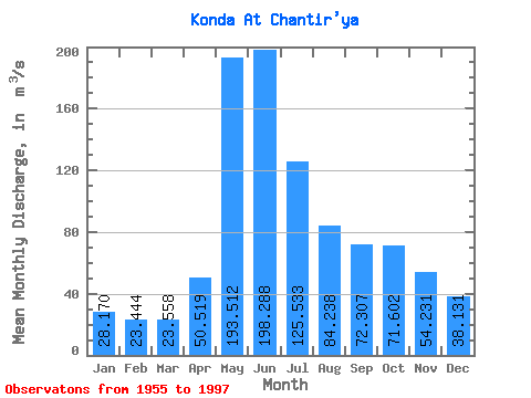
| Statistic | Jan | Feb | Mar | Apr | May | Jun | Jul | Aug | Sep | Oct | Nov | Dec | Annual |
|---|---|---|---|---|---|---|---|---|---|---|---|---|---|
| Mean | 28.17 | 23.44 | 23.56 | 50.52 | 193.51 | 198.29 | 125.53 | 84.24 | 72.31 | 71.60 | 54.23 | 38.13 | 80.18 |
| Standard Deviation | 11.27 | 5.21 | 3.46 | 22.28 | 84.46 | 73.08 | 49.24 | 40.62 | 38.09 | 38.36 | 29.21 | 19.95 | 22.18 |
| Min | 16.20 | 15.40 | 17.70 | 23.20 | 24.40 | 74.20 | 38.00 | 26.40 | 30.70 | 22.00 | 17.20 | 15.40 | 40.37 |
| Max | 60.60 | 39.00 | 35.50 | 133.00 | 402.00 | 374.00 | 287.00 | 184.00 | 164.00 | 175.00 | 134.00 | 96.80 | 131.10 |
| Coefficient of Variation | 0.40 | 0.22 | 0.15 | 0.44 | 0.44 | 0.37 | 0.39 | 0.48 | 0.53 | 0.54 | 0.54 | 0.52 | 0.28 |
 Return to R-Arctic Net Home Page