|
|
|||||||||||||||||
| Point ID: 7086 | Downloads | Plots | Site Data | Code: 11502 |
|
|
|||||||||||||||||
| Download | |
|---|---|
| Site Descriptor Information | Site Time Series Data |
| Link to all available data | |
| View: | Time Series | All |
| Units: | m3/s |
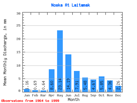
| Statistic | Jan | Feb | Mar | Apr | May | Jun | Jul | Aug | Sep | Oct | Nov | Dec | Annual |
|---|---|---|---|---|---|---|---|---|---|---|---|---|---|
| Mean | 1.16 | 0.69 | 0.65 | 8.60 | 23.14 | 14.19 | 7.91 | 5.48 | 4.67 | 5.85 | 4.36 | 2.26 | 76.72 |
| Standard Deviation | 0.95 | 0.50 | 0.42 | 7.81 | 11.73 | 10.62 | 7.10 | 6.11 | 5.31 | 6.16 | 4.79 | 2.27 | 45.99 |
| Min | 0.21 | 0.21 | 0.19 | 0.58 | 4.66 | 1.95 | 0.93 | 0.47 | 0.42 | 0.42 | 0.38 | 0.31 | 18.72 |
| Max | 4.23 | 2.23 | 2.21 | 38.23 | 42.26 | 39.38 | 33.93 | 31.91 | 28.29 | 27.18 | 18.46 | 9.52 | 231.23 |
| Coefficient of Variation | 0.82 | 0.72 | 0.65 | 0.91 | 0.51 | 0.75 | 0.90 | 1.11 | 1.14 | 1.05 | 1.10 | 1.00 | 0.60 |
 Return to R-Arctic Net Home Page