|
|
|||||||||||||||||
| Point ID: 7086 | Downloads | Plots | Site Data | Code: 11502 |
|
|
|||||||||||||||||
| Download | |
|---|---|
| Site Descriptor Information | Site Time Series Data |
| Link to all available data | |
| View: | Time Series | All |
| Units: | mm |
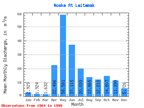
| Statistic | Jan | Feb | Mar | Apr | May | Jun | Jul | Aug | Sep | Oct | Nov | Dec | Annual |
|---|---|---|---|---|---|---|---|---|---|---|---|---|---|
| Mean | 2.93 | 1.92 | 1.63 | 22.49 | 58.58 | 37.12 | 20.03 | 13.87 | 12.21 | 14.81 | 11.40 | 5.73 | 16.48 |
| Standard Deviation | 2.41 | 1.38 | 1.06 | 20.42 | 29.70 | 27.77 | 17.97 | 15.46 | 13.89 | 15.58 | 12.54 | 5.74 | 9.88 |
| Min | 0.53 | 0.58 | 0.48 | 1.53 | 11.80 | 5.11 | 2.35 | 1.20 | 1.11 | 1.06 | 1.00 | 0.78 | 4.02 |
| Max | 10.70 | 6.20 | 5.59 | 100.00 | 107.00 | 103.00 | 85.90 | 80.80 | 74.00 | 68.80 | 48.30 | 24.10 | 49.67 |
| Coefficient of Variation | 0.82 | 0.72 | 0.65 | 0.91 | 0.51 | 0.75 | 0.90 | 1.11 | 1.14 | 1.05 | 1.10 | 1.00 | 0.60 |
 Return to R-Arctic Net Home Page