|
|
|||||||||||||||||
| Point ID: 7083 | Downloads | Plots | Site Data | Code: 11496 |
|
|
|||||||||||||||||
| Download | |
|---|---|
| Site Descriptor Information | Site Time Series Data |
| Link to all available data | |
| View: | Time Series | All |
| Units: | m3/s |
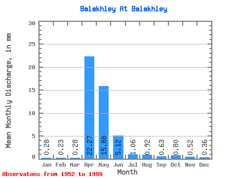
| Statistic | Jan | Feb | Mar | Apr | May | Jun | Jul | Aug | Sep | Oct | Nov | Dec | Annual |
|---|---|---|---|---|---|---|---|---|---|---|---|---|---|
| Mean | 0.28 | 0.23 | 0.28 | 22.27 | 15.88 | 5.12 | 1.05 | 0.92 | 0.63 | 0.80 | 0.52 | 0.36 | 48.44 |
| Standard Deviation | 0.17 | 0.12 | 0.15 | 19.75 | 19.74 | 10.89 | 1.68 | 1.79 | 0.92 | 1.18 | 0.46 | 0.39 | 43.74 |
| Min | 0.06 | 0.05 | 0.07 | 2.07 | 0.38 | 0.11 | 0.10 | 0.08 | 0.08 | 0.10 | 0.09 | 0.06 | 5.16 |
| Max | 1.06 | 0.50 | 0.90 | 74.37 | 77.84 | 53.29 | 8.38 | 10.26 | 6.27 | 6.82 | 2.82 | 2.78 | 180.88 |
| Coefficient of Variation | 0.62 | 0.52 | 0.52 | 0.89 | 1.24 | 2.13 | 1.59 | 1.94 | 1.45 | 1.47 | 0.88 | 1.07 | 0.90 |
 Return to R-Arctic Net Home Page