|
|
|||||||||||||||||
| Point ID: 7083 | Downloads | Plots | Site Data | Code: 11496 |
|
|
|||||||||||||||||
| Download | |
|---|---|
| Site Descriptor Information | Site Time Series Data |
| Link to all available data | |
| View: | Time Series | All |
| Units: | mm |
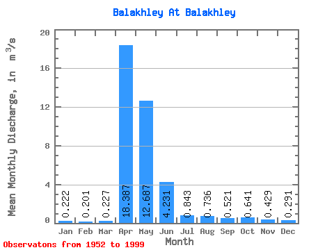
| Statistic | Jan | Feb | Mar | Apr | May | Jun | Jul | Aug | Sep | Oct | Nov | Dec | Annual |
|---|---|---|---|---|---|---|---|---|---|---|---|---|---|
| Mean | 0.22 | 0.20 | 0.23 | 18.39 | 12.69 | 4.23 | 0.84 | 0.74 | 0.52 | 0.64 | 0.43 | 0.29 | 3.29 |
| Standard Deviation | 0.14 | 0.10 | 0.12 | 16.31 | 15.77 | 8.99 | 1.34 | 1.43 | 0.76 | 0.94 | 0.38 | 0.31 | 2.97 |
| Min | 0.05 | 0.04 | 0.06 | 1.71 | 0.30 | 0.09 | 0.08 | 0.06 | 0.06 | 0.08 | 0.08 | 0.05 | 0.35 |
| Max | 0.85 | 0.44 | 0.72 | 61.40 | 62.20 | 44.00 | 6.70 | 8.20 | 5.18 | 5.45 | 2.33 | 2.22 | 12.27 |
| Coefficient of Variation | 0.62 | 0.52 | 0.52 | 0.89 | 1.24 | 2.13 | 1.59 | 1.94 | 1.45 | 1.47 | 0.88 | 1.07 | 0.90 |
 Return to R-Arctic Net Home Page