|
|
|||||||||||||||||
| Point ID: 7030 | Downloads | Plots | Site Data | Code: 11353 |
|
|
|||||||||||||||||
| Download | |
|---|---|
| Site Descriptor Information | Site Time Series Data |
| Link to all available data | |
| View: | Time Series | All |
| Units: | m3/s |
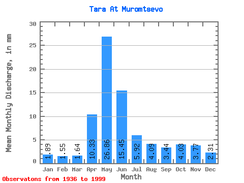
| Statistic | Jan | Feb | Mar | Apr | May | Jun | Jul | Aug | Sep | Oct | Nov | Dec | Annual |
|---|---|---|---|---|---|---|---|---|---|---|---|---|---|
| Mean | 1.89 | 1.56 | 1.64 | 10.33 | 26.86 | 15.45 | 5.92 | 4.09 | 3.44 | 4.03 | 3.77 | 2.31 | 81.06 |
| Standard Deviation | 0.66 | 0.49 | 0.41 | 6.50 | 14.43 | 13.75 | 4.54 | 3.17 | 2.45 | 2.78 | 2.70 | 0.98 | 39.45 |
| Min | 0.90 | 0.84 | 0.99 | 1.58 | 2.45 | 1.75 | 1.09 | 0.95 | 0.72 | 0.89 | 1.03 | 1.09 | 20.77 |
| Max | 4.05 | 2.96 | 2.79 | 28.61 | 62.38 | 63.22 | 26.13 | 14.76 | 12.87 | 12.74 | 17.23 | 5.75 | 209.81 |
| Coefficient of Variation | 0.35 | 0.32 | 0.25 | 0.63 | 0.54 | 0.89 | 0.77 | 0.78 | 0.71 | 0.69 | 0.72 | 0.43 | 0.49 |
 Return to R-Arctic Net Home Page