|
|
|||||||||||||||||
| Point ID: 7030 | Downloads | Plots | Site Data | Code: 11353 |
|
|
|||||||||||||||||
| Download | |
|---|---|
| Site Descriptor Information | Site Time Series Data |
| Link to all available data | |
| View: | Time Series | All |
| Units: | mm |
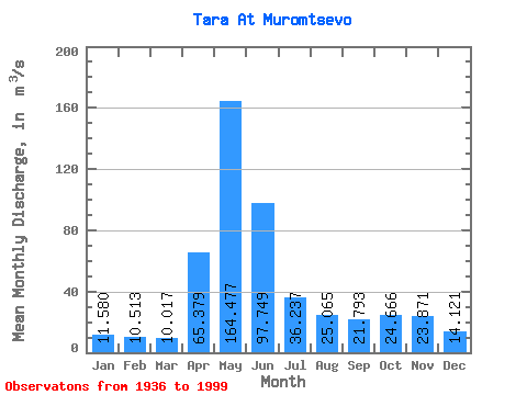
| Statistic | Jan | Feb | Mar | Apr | May | Jun | Jul | Aug | Sep | Oct | Nov | Dec | Annual |
|---|---|---|---|---|---|---|---|---|---|---|---|---|---|
| Mean | 11.58 | 10.51 | 10.02 | 65.38 | 164.48 | 97.75 | 36.24 | 25.07 | 21.79 | 24.67 | 23.87 | 14.12 | 42.12 |
| Standard Deviation | 4.05 | 3.32 | 2.54 | 41.14 | 88.35 | 87.00 | 27.84 | 19.44 | 15.51 | 17.02 | 17.10 | 6.03 | 20.50 |
| Min | 5.53 | 5.63 | 6.08 | 10.00 | 15.00 | 11.10 | 6.67 | 5.80 | 4.56 | 5.45 | 6.51 | 6.66 | 10.79 |
| Max | 24.80 | 19.90 | 17.10 | 181.00 | 382.00 | 400.00 | 160.00 | 90.40 | 81.40 | 78.00 | 109.00 | 35.20 | 109.03 |
| Coefficient of Variation | 0.35 | 0.32 | 0.25 | 0.63 | 0.54 | 0.89 | 0.77 | 0.78 | 0.71 | 0.69 | 0.72 | 0.43 | 0.49 |
 Return to R-Arctic Net Home Page