|
|
|||||||||||||||||
| Point ID: 6996 | Downloads | Plots | Site Data | Code: 11240 |
|
|
|||||||||||||||||
| Download | |
|---|---|
| Site Descriptor Information | Site Time Series Data |
| Link to all available data | |
| View: | Time Series | All |
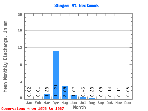
| Units: | m3/s |
| Statistic | Jan | Feb | Mar | Apr | May | Jun | Jul | Aug | Sep | Oct | Nov | Dec | Annual |
|---|---|---|---|---|---|---|---|---|---|---|---|---|---|
| Mean | 0.02 | 0.01 | 1.28 | 11.21 | 3.09 | 1.02 | 0.46 | 0.23 | 0.09 | 0.14 | 0.11 | 0.06 | 20.70 |
| Standard Deviation | 0.02 | 0.02 | 3.07 | 9.09 | 3.23 | 1.35 | 0.99 | 0.30 | 0.09 | 0.20 | 0.11 | 0.04 | |
| Min | 0.00 | 0.00 | 0.00 | 0.56 | 0.41 | 0.04 | 0.00 | 0.01 | 0.00 | 0.00 | 0.00 | 0.00 | 20.70 |
| Max | 0.04 | 0.04 | 10.00 | 28.39 | 15.30 | 6.27 | 4.43 | 1.02 | 0.25 | 0.65 | 0.27 | 0.11 | 20.70 |
| Coefficient of Variation | 1.04 | 1.73 | 2.40 | 0.81 | 1.04 | 1.33 | 2.15 | 1.29 | 0.98 | 1.37 | 1.01 | 0.76 |
 Return to R-Arctic Net Home Page