|
|
|||||||||||||||||
| Point ID: 6996 | Downloads | Plots | Site Data | Code: 11240 |
|
|
|||||||||||||||||
| Download | |
|---|---|
| Site Descriptor Information | Site Time Series Data |
| Link to all available data | |
| View: | Time Series | All |
| Units: | mm |
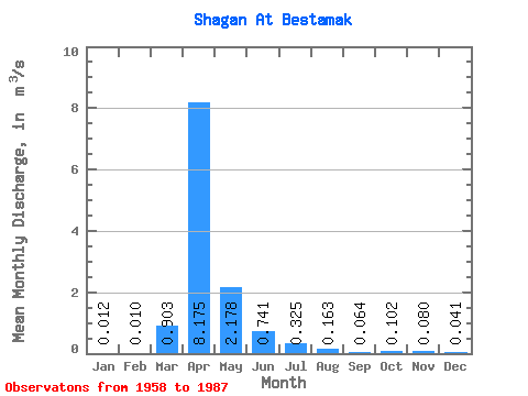
| Statistic | Jan | Feb | Mar | Apr | May | Jun | Jul | Aug | Sep | Oct | Nov | Dec | Annual |
|---|---|---|---|---|---|---|---|---|---|---|---|---|---|
| Mean | 0.01 | 0.01 | 0.90 | 8.18 | 2.18 | 0.74 | 0.33 | 0.16 | 0.06 | 0.10 | 0.08 | 0.04 | 1.24 |
| Standard Deviation | 0.01 | 0.02 | 2.17 | 6.62 | 2.28 | 0.98 | 0.70 | 0.21 | 0.06 | 0.14 | 0.08 | 0.03 | |
| Min | 0.00 | 0.00 | 0.00 | 0.41 | 0.29 | 0.03 | 0.00 | 0.00 | 0.00 | 0.00 | 0.00 | 0.00 | 1.24 |
| Max | 0.03 | 0.03 | 7.06 | 20.70 | 10.80 | 4.57 | 3.13 | 0.72 | 0.18 | 0.46 | 0.20 | 0.08 | 1.24 |
| Coefficient of Variation | 1.04 | 1.73 | 2.40 | 0.81 | 1.04 | 1.33 | 2.15 | 1.29 | 0.98 | 1.37 | 1.01 | 0.76 |
 Return to R-Arctic Net Home Page