|
|
|||||||||||||||||
| Point ID: 6984 | Downloads | Plots | Site Data | Code: 11164 |
|
|
|||||||||||||||||
| Download | |
|---|---|
| Site Descriptor Information | Site Time Series Data |
| Link to all available data | |
| View: | Time Series | All |
| Units: | m3/s |
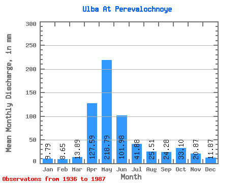
| Statistic | Jan | Feb | Mar | Apr | May | Jun | Jul | Aug | Sep | Oct | Nov | Dec | Annual |
|---|---|---|---|---|---|---|---|---|---|---|---|---|---|
| Mean | 9.79 | 8.73 | 13.89 | 127.59 | 218.75 | 101.98 | 41.88 | 25.51 | 24.28 | 33.10 | 20.88 | 11.86 | 636.58 |
| Standard Deviation | 2.61 | 2.09 | 6.47 | 43.01 | 89.65 | 58.40 | 26.27 | 17.73 | 23.56 | 21.73 | 9.64 | 4.41 | 179.85 |
| Min | 5.46 | 4.48 | 4.65 | 22.75 | 91.27 | 22.01 | 6.83 | 4.86 | 6.24 | 9.07 | 8.41 | 4.79 | 317.26 |
| Max | 15.52 | 13.94 | 45.31 | 217.94 | 527.95 | 290.41 | 122.97 | 79.79 | 165.04 | 107.67 | 47.03 | 23.83 | 1032.57 |
| Coefficient of Variation | 0.27 | 0.24 | 0.47 | 0.34 | 0.41 | 0.57 | 0.63 | 0.69 | 0.97 | 0.66 | 0.46 | 0.37 | 0.28 |
 Return to R-Arctic Net Home Page