|
|
|||||||||||||||||
| Point ID: 6984 | Downloads | Plots | Site Data | Code: 11164 |
|
|
|||||||||||||||||
| Download | |
|---|---|
| Site Descriptor Information | Site Time Series Data |
| Link to all available data | |
| View: | Time Series | All |
| Units: | mm |
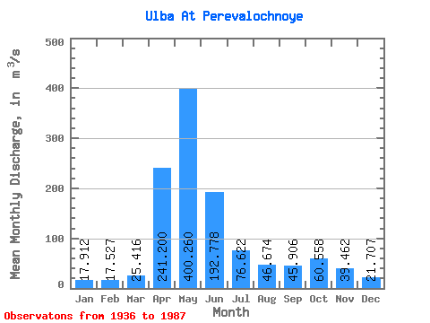
| Statistic | Jan | Feb | Mar | Apr | May | Jun | Jul | Aug | Sep | Oct | Nov | Dec | Annual |
|---|---|---|---|---|---|---|---|---|---|---|---|---|---|
| Mean | 17.91 | 17.53 | 25.42 | 241.20 | 400.26 | 192.78 | 76.62 | 46.67 | 45.91 | 60.56 | 39.46 | 21.71 | 98.83 |
| Standard Deviation | 4.78 | 4.19 | 11.84 | 81.30 | 164.03 | 110.40 | 48.06 | 32.45 | 44.53 | 39.77 | 18.22 | 8.07 | 27.92 |
| Min | 10.00 | 9.00 | 8.50 | 43.00 | 167.00 | 41.60 | 12.50 | 8.90 | 11.80 | 16.60 | 15.90 | 8.77 | 49.26 |
| Max | 28.40 | 28.00 | 82.90 | 412.00 | 966.00 | 549.00 | 225.00 | 146.00 | 312.00 | 197.00 | 88.90 | 43.60 | 160.32 |
| Coefficient of Variation | 0.27 | 0.24 | 0.47 | 0.34 | 0.41 | 0.57 | 0.63 | 0.69 | 0.97 | 0.66 | 0.46 | 0.37 | 0.28 |
 Return to R-Arctic Net Home Page