|
|
|||||||||||||||||
| Point ID: 6978 | Downloads | Plots | Site Data | Code: 11144 |
|
|
|||||||||||||||||
| Download | |
|---|---|
| Site Descriptor Information | Site Time Series Data |
| Link to all available data | |
| View: | Time Series | All |
| Units: | m3/s |
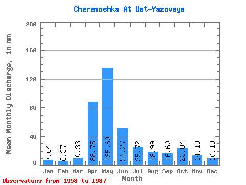
| Statistic | Jan | Feb | Mar | Apr | May | Jun | Jul | Aug | Sep | Oct | Nov | Dec | Annual |
|---|---|---|---|---|---|---|---|---|---|---|---|---|---|
| Mean | 7.64 | 6.42 | 10.32 | 88.75 | 135.58 | 51.27 | 25.72 | 18.99 | 16.60 | 23.83 | 14.18 | 10.13 | 400.37 |
| Standard Deviation | 2.05 | 1.95 | 5.31 | 29.59 | 62.34 | 31.05 | 15.53 | 12.10 | 9.38 | 14.54 | 6.25 | 3.58 | 123.77 |
| Min | 4.83 | 3.26 | 5.01 | 26.67 | 51.12 | 14.26 | 7.34 | 6.62 | 6.81 | 8.71 | 6.81 | 5.96 | 214.38 |
| Max | 12.76 | 10.32 | 28.21 | 148.36 | 336.99 | 128.73 | 69.19 | 63.82 | 48.90 | 63.22 | 29.21 | 19.50 | 663.36 |
| Coefficient of Variation | 0.27 | 0.30 | 0.51 | 0.33 | 0.46 | 0.61 | 0.60 | 0.64 | 0.56 | 0.61 | 0.44 | 0.35 | 0.31 |
 Return to R-Arctic Net Home Page