|
|
|||||||||||||||||
| Point ID: 6978 | Downloads | Plots | Site Data | Code: 11144 |
|
|
|||||||||||||||||
| Download | |
|---|---|
| Site Descriptor Information | Site Time Series Data |
| Link to all available data | |
| View: | Time Series | All |
| Units: | mm |
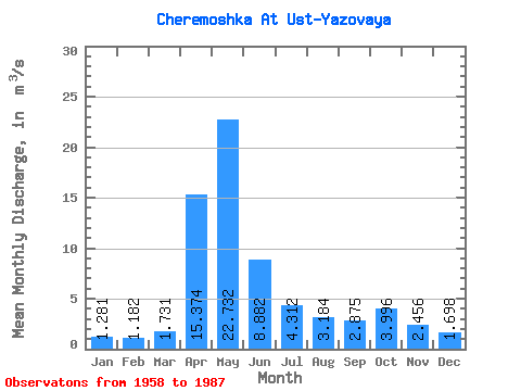
| Statistic | Jan | Feb | Mar | Apr | May | Jun | Jul | Aug | Sep | Oct | Nov | Dec | Annual |
|---|---|---|---|---|---|---|---|---|---|---|---|---|---|
| Mean | 1.28 | 1.18 | 1.73 | 15.37 | 22.73 | 8.88 | 4.31 | 3.18 | 2.88 | 4.00 | 2.46 | 1.70 | 5.70 |
| Standard Deviation | 0.34 | 0.36 | 0.89 | 5.12 | 10.45 | 5.38 | 2.60 | 2.03 | 1.62 | 2.44 | 1.08 | 0.60 | 1.76 |
| Min | 0.81 | 0.60 | 0.84 | 4.62 | 8.57 | 2.47 | 1.23 | 1.11 | 1.18 | 1.46 | 1.18 | 1.00 | 3.05 |
| Max | 2.14 | 1.90 | 4.73 | 25.70 | 56.50 | 22.30 | 11.60 | 10.70 | 8.47 | 10.60 | 5.06 | 3.27 | 9.44 |
| Coefficient of Variation | 0.27 | 0.30 | 0.51 | 0.33 | 0.46 | 0.61 | 0.60 | 0.64 | 0.56 | 0.61 | 0.44 | 0.35 | 0.31 |
 Return to R-Arctic Net Home Page