|
|
|||||||||||||||||
| Point ID: 6976 | Downloads | Plots | Site Data | Code: 11141 |
|
|
|||||||||||||||||
| Download | |
|---|---|
| Site Descriptor Information | Site Time Series Data |
| Link to all available data | |
| View: | Time Series | All |
| Units: | m3/s |
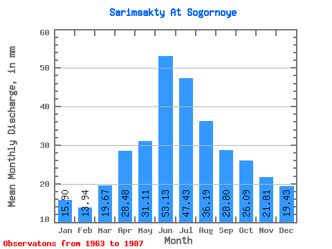
| Statistic | Jan | Feb | Mar | Apr | May | Jun | Jul | Aug | Sep | Oct | Nov | Dec | Annual |
|---|---|---|---|---|---|---|---|---|---|---|---|---|---|
| Mean | 15.90 | 14.06 | 19.67 | 28.48 | 31.10 | 53.13 | 47.42 | 36.18 | 28.80 | 26.09 | 21.81 | 19.42 | 341.58 |
| Standard Deviation | 3.88 | 3.09 | 3.92 | 6.79 | 9.87 | 24.06 | 18.36 | 9.78 | 6.70 | 4.77 | 4.23 | 7.09 | 78.16 |
| Min | 9.88 | 10.20 | 13.62 | 16.24 | 15.24 | 20.98 | 19.88 | 20.44 | 18.71 | 18.73 | 15.16 | 12.18 | 236.66 |
| Max | 25.29 | 21.84 | 28.82 | 47.39 | 59.61 | 124.45 | 89.41 | 55.77 | 44.51 | 33.04 | 29.01 | 39.51 | 527.46 |
| Coefficient of Variation | 0.24 | 0.22 | 0.20 | 0.24 | 0.32 | 0.45 | 0.39 | 0.27 | 0.23 | 0.18 | 0.19 | 0.36 | 0.23 |
 Return to R-Arctic Net Home Page