|
|
|||||||||||||||||
| Point ID: 6976 | Downloads | Plots | Site Data | Code: 11141 |
|
|
|||||||||||||||||
| Download | |
|---|---|
| Site Descriptor Information | Site Time Series Data |
| Link to all available data | |
| View: | Time Series | All |
| Units: | mm |
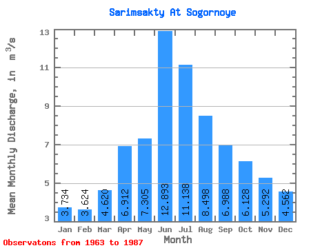
| Statistic | Jan | Feb | Mar | Apr | May | Jun | Jul | Aug | Sep | Oct | Nov | Dec | Annual |
|---|---|---|---|---|---|---|---|---|---|---|---|---|---|
| Mean | 3.73 | 3.62 | 4.62 | 6.91 | 7.30 | 12.89 | 11.14 | 8.50 | 6.99 | 6.13 | 5.29 | 4.56 | 6.81 |
| Standard Deviation | 0.91 | 0.80 | 0.92 | 1.65 | 2.32 | 5.84 | 4.31 | 2.30 | 1.62 | 1.12 | 1.03 | 1.67 | 1.56 |
| Min | 2.32 | 2.63 | 3.20 | 3.94 | 3.58 | 5.09 | 4.67 | 4.80 | 4.54 | 4.40 | 3.68 | 2.86 | 4.72 |
| Max | 5.94 | 5.63 | 6.77 | 11.50 | 14.00 | 30.20 | 21.00 | 13.10 | 10.80 | 7.76 | 7.04 | 9.28 | 10.51 |
| Coefficient of Variation | 0.24 | 0.22 | 0.20 | 0.24 | 0.32 | 0.45 | 0.39 | 0.27 | 0.23 | 0.18 | 0.19 | 0.36 | 0.23 |
 Return to R-Arctic Net Home Page