|
|
|||||||||||||||||
| Point ID: 6966 | Downloads | Plots | Site Data | Code: 11094 |
|
|
|||||||||||||||||
| Download | |
|---|---|
| Site Descriptor Information | Site Time Series Data |
| Link to all available data | |
| View: | Time Series | All |
| Units: | m3/s |
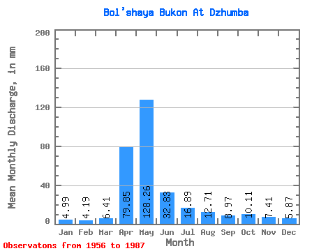
| Statistic | Jan | Feb | Mar | Apr | May | Jun | Jul | Aug | Sep | Oct | Nov | Dec | Annual |
|---|---|---|---|---|---|---|---|---|---|---|---|---|---|
| Mean | 4.99 | 4.22 | 6.40 | 79.85 | 128.24 | 32.83 | 16.89 | 12.71 | 8.97 | 10.11 | 7.41 | 5.87 | 318.99 |
| Standard Deviation | 2.91 | 2.19 | 4.86 | 39.08 | 81.26 | 19.29 | 10.98 | 11.74 | 5.67 | 6.55 | 5.33 | 4.11 | 128.29 |
| Min | 2.12 | 1.35 | 1.56 | 24.48 | 28.41 | 9.13 | 5.12 | 3.53 | 3.25 | 4.17 | 2.77 | 2.54 | 111.13 |
| Max | 16.92 | 11.23 | 26.78 | 161.40 | 388.63 | 83.78 | 52.29 | 62.53 | 22.91 | 33.03 | 31.94 | 25.30 | 651.29 |
| Coefficient of Variation | 0.58 | 0.52 | 0.76 | 0.49 | 0.63 | 0.59 | 0.65 | 0.92 | 0.63 | 0.65 | 0.72 | 0.70 | 0.40 |
 Return to R-Arctic Net Home Page