|
|
|||||||||||||||||
| Point ID: 6966 | Downloads | Plots | Site Data | Code: 11094 |
|
|
|||||||||||||||||
| Download | |
|---|---|
| Site Descriptor Information | Site Time Series Data |
| Link to all available data | |
| View: | Time Series | All |
| Units: | mm |
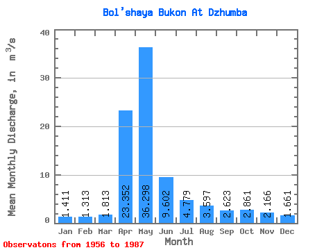
| Statistic | Jan | Feb | Mar | Apr | May | Jun | Jul | Aug | Sep | Oct | Nov | Dec | Annual |
|---|---|---|---|---|---|---|---|---|---|---|---|---|---|
| Mean | 1.41 | 1.31 | 1.81 | 23.35 | 36.30 | 9.60 | 4.78 | 3.60 | 2.62 | 2.86 | 2.17 | 1.66 | 7.66 |
| Standard Deviation | 0.82 | 0.68 | 1.38 | 11.43 | 23.00 | 5.64 | 3.11 | 3.32 | 1.66 | 1.85 | 1.56 | 1.16 | 3.08 |
| Min | 0.60 | 0.42 | 0.44 | 7.16 | 8.04 | 2.67 | 1.45 | 1.00 | 0.95 | 1.18 | 0.81 | 0.72 | 2.67 |
| Max | 4.79 | 3.49 | 7.58 | 47.20 | 110.00 | 24.50 | 14.80 | 17.70 | 6.70 | 9.35 | 9.34 | 7.16 | 15.64 |
| Coefficient of Variation | 0.58 | 0.52 | 0.76 | 0.49 | 0.63 | 0.59 | 0.65 | 0.92 | 0.63 | 0.65 | 0.72 | 0.70 | 0.40 |
 Return to R-Arctic Net Home Page