|
|
|||||||||||||||||
| Point ID: 6942 | Downloads | Plots | Site Data | Code: 10654 |
|
|
|||||||||||||||||
| Download | |
|---|---|
| Site Descriptor Information | Site Time Series Data |
| Link to all available data | |
| View: | Time Series | All |
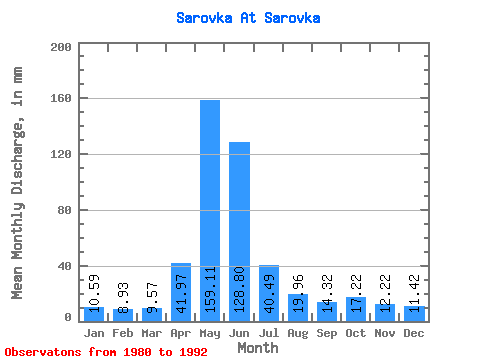
| Units: | m3/s |
| Statistic | Jan | Feb | Mar | Apr | May | Jun | Jul | Aug | Sep | Oct | Nov | Dec | Annual |
|---|---|---|---|---|---|---|---|---|---|---|---|---|---|
| Mean | 10.61 | 8.98 | 9.56 | 41.97 | 159.12 | 128.80 | 40.49 | 19.96 | 14.32 | 17.22 | 12.21 | 11.42 | 477.88 |
| Standard Deviation | 2.69 | 2.51 | 2.47 | 23.52 | 77.43 | 83.43 | 31.59 | 17.37 | 5.97 | 7.71 | 3.52 | 3.31 | 186.96 |
| Min | 6.38 | 6.39 | 6.38 | 6.79 | 47.82 | 32.71 | 8.93 | 7.01 | 8.02 | 8.29 | 5.92 | 7.65 | 293.06 |
| Max | 14.66 | 14.52 | 14.66 | 78.38 | 280.55 | 253.03 | 96.92 | 66.31 | 25.92 | 32.52 | 18.51 | 18.49 | 784.62 |
| Coefficient of Variation | 0.25 | 0.28 | 0.26 | 0.56 | 0.49 | 0.65 | 0.78 | 0.87 | 0.42 | 0.45 | 0.29 | 0.29 | 0.39 |
 Return to R-Arctic Net Home Page