|
|
|||||||||||||||||
| Point ID: 6942 | Downloads | Plots | Site Data | Code: 10654 |
|
|
|||||||||||||||||
| Download | |
|---|---|
| Site Descriptor Information | Site Time Series Data |
| Link to all available data | |
|
|
| View: | Statistics | Time Series |
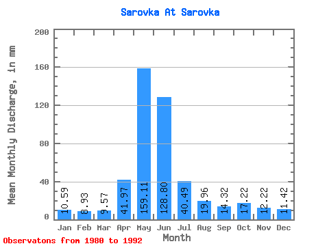
| Units: | m3/s |
| Statistic | Jan | Feb | Mar | Apr | May | Jun | Jul | Aug | Sep | Oct | Nov | Dec | Annual |
|---|---|---|---|---|---|---|---|---|---|---|---|---|---|
| Mean | 10.61 | 8.98 | 9.56 | 41.97 | 159.12 | 128.80 | 40.49 | 19.96 | 14.32 | 17.22 | 12.21 | 11.42 | 477.88 |
| Standard Deviation | 2.69 | 2.51 | 2.47 | 23.52 | 77.43 | 83.43 | 31.59 | 17.37 | 5.97 | 7.71 | 3.52 | 3.31 | 186.96 |
| Min | 6.38 | 6.39 | 6.38 | 6.79 | 47.82 | 32.71 | 8.93 | 7.01 | 8.02 | 8.29 | 5.92 | 7.65 | 293.06 |
| Max | 14.66 | 14.52 | 14.66 | 78.38 | 280.55 | 253.03 | 96.92 | 66.31 | 25.92 | 32.52 | 18.51 | 18.49 | 784.62 |
| Coefficient of Variation | 0.25 | 0.28 | 0.26 | 0.56 | 0.49 | 0.65 | 0.78 | 0.87 | 0.42 | 0.45 | 0.29 | 0.29 | 0.39 |
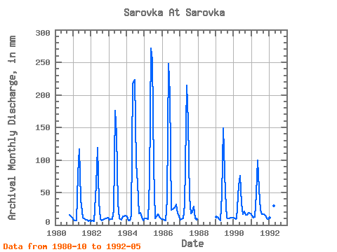
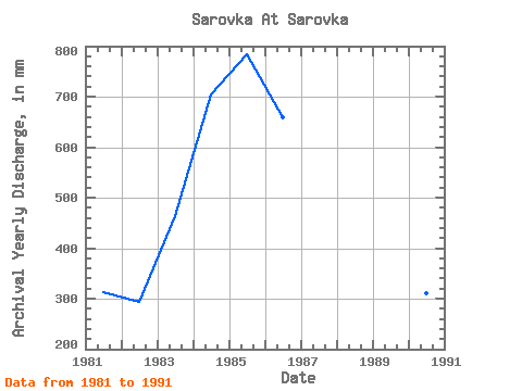
| Year | Jan | Feb | Mar | Apr | May | Jun | Jul | Aug | Sep | Oct | Nov | Dec | Annual | 1980 | 15.94 | 13.58 | 12.12 | 1981 | 8.29 | 6.97 | 7.65 | 78.38 | 120.51 | 39.50 | 12.12 | 10.20 | 8.02 | 8.29 | 5.92 | 7.65 | 312.85 | 1982 | 6.38 | 6.39 | 6.38 | 62.33 | 122.42 | 34.56 | 8.93 | 7.01 | 8.02 | 9.56 | 10.49 | 11.48 | 293.06 | 1983 | 8.29 | 8.13 | 9.56 | 22.22 | 181.08 | 139.47 | 35.07 | 10.20 | 8.02 | 14.03 | 13.58 | 14.66 | 462.75 | 1984 | 14.03 | 6.39 | 7.01 | 14.19 | 225.08 | 222.79 | 96.92 | 66.31 | 17.28 | 19.13 | 12.34 | 7.65 | 705.72 | 1985 | 10.20 | 9.29 | 9.56 | 68.50 | 280.55 | 253.03 | 93.09 | 10.20 | 13.58 | 17.22 | 11.73 | 9.56 | 784.62 | 1986 | 9.56 | 7.55 | 7.65 | 39.50 | 256.32 | 201.81 | 23.59 | 26.14 | 25.92 | 32.52 | 17.28 | 14.03 | 660.00 | 1987 | 8.29 | 8.71 | 10.20 | 30.86 | 221.89 | 159.84 | 43.36 | 18.49 | 19.75 | 29.97 | 9.87 | 8.93 | 567.96 | 1989 | 12.75 | 11.62 | 9.56 | 6.79 | 47.82 | 149.35 | 50.37 | 12.12 | 9.87 | 10.84 | 11.11 | 11.48 | 344.40 | 1990 | 12.12 | 8.13 | 10.20 | 61.10 | 78.43 | 32.71 | 17.22 | 21.68 | 16.05 | 16.58 | 18.51 | 18.49 | 310.59 | 1991 | 14.66 | 11.04 | 12.75 | 48.14 | 103.29 | 54.93 | 24.23 | 17.22 | 16.66 | 15.30 | 9.87 | 9.56 | 336.89 | 1992 | 12.12 | 14.52 | 14.66 | 29.62 | 112.86 |
|---|
 Return to R-Arctic Net Home Page