|
|
|||||||||||||||||
| Point ID: 6918 | Downloads | Plots | Site Data | Code: 10582 |
|
|
|||||||||||||||||
| Download | |
|---|---|
| Site Descriptor Information | Site Time Series Data |
| Link to all available data | |
| View: | Time Series | All |
| Units: | m3/s |
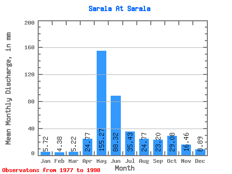
| Statistic | Jan | Feb | Mar | Apr | May | Jun | Jul | Aug | Sep | Oct | Nov | Dec | Annual |
|---|---|---|---|---|---|---|---|---|---|---|---|---|---|
| Mean | 5.72 | 4.42 | 5.21 | 24.77 | 155.25 | 88.32 | 35.43 | 24.77 | 23.20 | 29.07 | 16.46 | 8.89 | 410.08 |
| Standard Deviation | 1.56 | 1.71 | 1.78 | 23.71 | 40.92 | 35.89 | 10.52 | 9.64 | 11.41 | 12.66 | 6.81 | 3.01 | 84.73 |
| Min | 2.66 | 2.38 | 3.09 | 6.63 | 103.85 | 30.07 | 13.02 | 11.16 | 9.20 | 10.28 | 7.34 | 4.97 | 241.50 |
| Max | 8.26 | 8.61 | 10.22 | 100.32 | 235.09 | 160.66 | 54.58 | 46.00 | 42.34 | 52.33 | 30.87 | 13.63 | 520.18 |
| Coefficient of Variation | 0.27 | 0.39 | 0.34 | 0.96 | 0.26 | 0.41 | 0.30 | 0.39 | 0.49 | 0.44 | 0.41 | 0.34 | 0.21 |
 Return to R-Arctic Net Home Page