|
|
|||||||||||||||||
| Point ID: 6918 | Downloads | Plots | Site Data | Code: 10582 |
|
|
|||||||||||||||||
| Download | |
|---|---|
| Site Descriptor Information | Site Time Series Data |
| Link to all available data | |
|
|
| View: | Statistics | Time Series |
| Units: | m3/s |
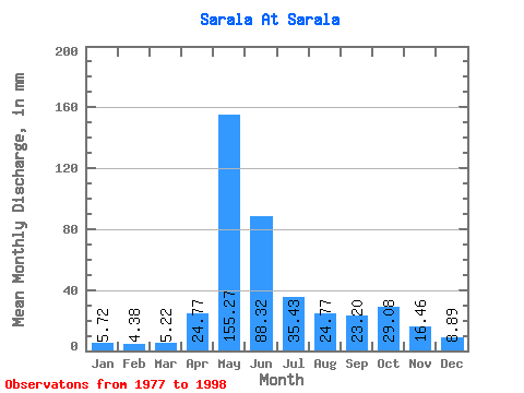
| Statistic | Jan | Feb | Mar | Apr | May | Jun | Jul | Aug | Sep | Oct | Nov | Dec | Annual |
|---|---|---|---|---|---|---|---|---|---|---|---|---|---|
| Mean | 5.72 | 4.42 | 5.21 | 24.77 | 155.25 | 88.32 | 35.43 | 24.77 | 23.20 | 29.07 | 16.46 | 8.89 | 410.08 |
| Standard Deviation | 1.56 | 1.71 | 1.78 | 23.71 | 40.92 | 35.89 | 10.52 | 9.64 | 11.41 | 12.66 | 6.81 | 3.01 | 84.73 |
| Min | 2.66 | 2.38 | 3.09 | 6.63 | 103.85 | 30.07 | 13.02 | 11.16 | 9.20 | 10.28 | 7.34 | 4.97 | 241.50 |
| Max | 8.26 | 8.61 | 10.22 | 100.32 | 235.09 | 160.66 | 54.58 | 46.00 | 42.34 | 52.33 | 30.87 | 13.63 | 520.18 |
| Coefficient of Variation | 0.27 | 0.39 | 0.34 | 0.96 | 0.26 | 0.41 | 0.30 | 0.39 | 0.49 | 0.44 | 0.41 | 0.34 | 0.21 |
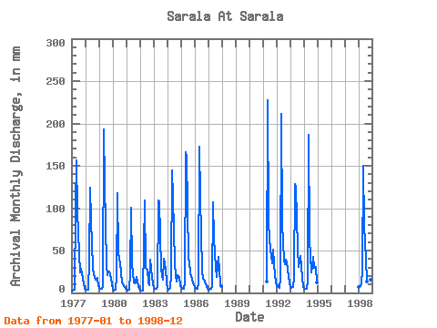
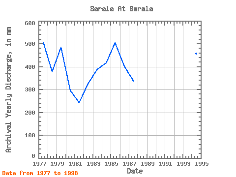
| Year | Jan | Feb | Mar | Apr | May | Jun | Jul | Aug | Sep | Oct | Nov | Dec | Annual | 1977 | 2.66 | 2.50 | 3.41 | 100.32 | 161.50 | 95.96 | 48.24 | 25.14 | 28.69 | 23.51 | 11.42 | 5.01 | 507.19 | 1978 | 4.64 | 3.43 | 4.13 | 39.77 | 128.59 | 85.08 | 30.66 | 23.10 | 17.87 | 16.58 | 17.33 | 8.01 | 377.94 | 1979 | 6.09 | 4.66 | 5.15 | 7.82 | 198.91 | 129.80 | 33.53 | 22.08 | 25.72 | 26.17 | 17.67 | 9.94 | 485.12 | 1980 | 6.13 | 2.89 | 4.15 | 20.38 | 122.04 | 46.70 | 35.77 | 25.35 | 12.74 | 10.28 | 7.34 | 5.19 | 296.73 | 1981 | 5.34 | 2.91 | 4.05 | 23.55 | 103.85 | 34.23 | 13.02 | 11.16 | 12.39 | 19.01 | 8.55 | 4.97 | 241.50 | 1982 | 3.66 | 2.38 | 3.09 | 54.02 | 112.64 | 30.07 | 28.82 | 13.23 | 9.20 | 40.07 | 18.70 | 11.92 | 325.80 | 1983 | 5.56 | 4.13 | 4.93 | 6.63 | 112.64 | 107.83 | 29.64 | 21.26 | 15.10 | 41.50 | 28.69 | 11.20 | 387.69 | 1984 | 6.17 | 3.76 | 5.64 | 21.57 | 149.03 | 113.77 | 36.18 | 20.85 | 13.41 | 21.26 | 18.68 | 7.97 | 416.62 | 1985 | 6.71 | 5.61 | 4.76 | 12.62 | 171.31 | 160.66 | 41.91 | 38.43 | 23.15 | 20.65 | 11.52 | 10.02 | 505.56 | 1986 | 6.44 | 5.29 | 5.42 | 11.22 | 178.26 | 112.39 | 26.78 | 16.72 | 15.23 | 13.53 | 7.83 | 5.19 | 402.35 | 1987 | 3.39 | 3.48 | 4.68 | 7.89 | 110.80 | 63.91 | 30.87 | 19.83 | 32.65 | 43.75 | 10.84 | 8.42 | 338.51 | 1991 | 13.08 | 235.09 | 82.11 | 51.11 | 46.00 | 35.02 | 52.33 | 19.73 | 13.63 | 1992 | 8.26 | 8.61 | 6.24 | 17.49 | 218.74 | 80.93 | 40.07 | 34.55 | 38.98 | 37.62 | 19.57 | 12.59 | 520.18 | 1993 | 7.48 | 6.02 | 7.65 | 18.38 | 133.29 | 124.65 | 54.58 | 32.09 | 38.38 | 44.56 | 18.62 | 7.65 | 491.61 | 1994 | 6.11 | 4.28 | 4.70 | 13.18 | 192.57 | 64.50 | 25.55 | 32.09 | 42.34 | 31.07 | 30.87 | 13.23 | 457.58 | 1998 | 7.16 | 6.39 | 10.22 | 28.49 | 154.75 | 80.53 | 40.07 | 14.43 | 10.35 | 23.30 | 16.09 | 7.24 | 396.89 |
|---|
 Return to R-Arctic Net Home Page