|
|
|||||||||||||||||
| Point ID: 6898 | Downloads | Plots | Site Data | Code: 10554 |
|
|
|||||||||||||||||
| Download | |
|---|---|
| Site Descriptor Information | Site Time Series Data |
| Link to all available data | |
| View: | Time Series | All |
| Units: | m3/s |
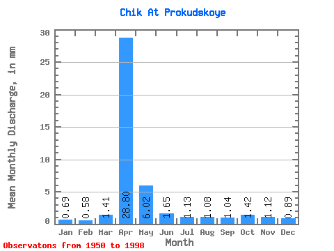
| Statistic | Jan | Feb | Mar | Apr | May | Jun | Jul | Aug | Sep | Oct | Nov | Dec | Annual |
|---|---|---|---|---|---|---|---|---|---|---|---|---|---|
| Mean | 0.69 | 0.58 | 1.41 | 28.80 | 6.02 | 1.65 | 1.14 | 1.07 | 1.04 | 1.42 | 1.12 | 0.89 | 47.15 |
| Standard Deviation | 0.32 | 0.37 | 1.85 | 16.03 | 4.81 | 1.07 | 0.59 | 0.56 | 0.44 | 0.51 | 0.43 | 0.41 | 19.42 |
| Min | 0.30 | 0.11 | 0.30 | 6.28 | 1.35 | 0.59 | 0.50 | 0.46 | 0.50 | 0.69 | 0.23 | 0.22 | 14.20 |
| Max | 1.55 | 2.04 | 9.94 | 71.81 | 27.57 | 4.95 | 3.04 | 3.11 | 2.55 | 2.68 | 2.15 | 2.04 | 93.61 |
| Coefficient of Variation | 0.47 | 0.63 | 1.32 | 0.56 | 0.80 | 0.65 | 0.52 | 0.53 | 0.42 | 0.36 | 0.38 | 0.46 | 0.41 |
 Return to R-Arctic Net Home Page