|
|
|||||||||||||||||
| Point ID: 6898 | Downloads | Plots | Site Data | Code: 10554 |
|
|
|||||||||||||||||
| Download | |
|---|---|
| Site Descriptor Information | Site Time Series Data |
| Link to all available data | |
| View: | Time Series | All |
| Units: | mm |
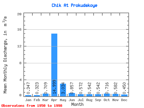
| Statistic | Jan | Feb | Mar | Apr | May | Jun | Jul | Aug | Sep | Oct | Nov | Dec | Annual |
|---|---|---|---|---|---|---|---|---|---|---|---|---|---|
| Mean | 0.35 | 0.32 | 0.71 | 15.00 | 3.03 | 0.86 | 0.57 | 0.54 | 0.54 | 0.72 | 0.58 | 0.45 | 2.02 |
| Standard Deviation | 0.16 | 0.20 | 0.94 | 8.35 | 2.42 | 0.56 | 0.30 | 0.28 | 0.23 | 0.26 | 0.22 | 0.21 | 0.83 |
| Min | 0.15 | 0.06 | 0.15 | 3.27 | 0.68 | 0.31 | 0.25 | 0.23 | 0.26 | 0.35 | 0.12 | 0.11 | 0.61 |
| Max | 0.78 | 1.13 | 5.01 | 37.40 | 13.90 | 2.58 | 1.53 | 1.57 | 1.33 | 1.35 | 1.12 | 1.03 | 4.00 |
| Coefficient of Variation | 0.47 | 0.63 | 1.32 | 0.56 | 0.80 | 0.65 | 0.52 | 0.53 | 0.42 | 0.36 | 0.38 | 0.46 | 0.41 |
 Return to R-Arctic Net Home Page