|
|
|||||||||||||||||
| Point ID: 6878 | Downloads | Plots | Site Data | Other Close Sites | Code: 10504 |
|
|
|||||||||||||||||
| Download | |
|---|---|
| Site Descriptor Information | Site Time Series Data |
| Link to all available data | |
| View: | Time Series | All |
| Units: | m3/s |
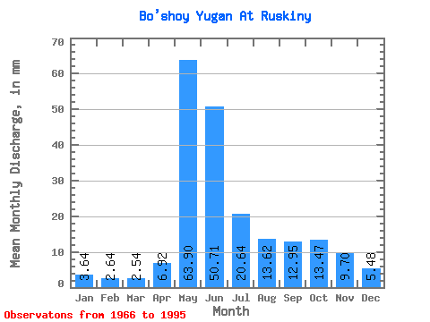
| Statistic | Jan | Feb | Mar | Apr | May | Jun | Jul | Aug | Sep | Oct | Nov | Dec | Annual |
|---|---|---|---|---|---|---|---|---|---|---|---|---|---|
| Mean | 3.64 | 2.67 | 2.54 | 6.92 | 63.89 | 50.71 | 20.64 | 13.62 | 12.95 | 13.47 | 9.70 | 5.48 | 206.90 |
| Standard Deviation | 1.12 | 0.64 | 0.34 | 7.70 | 16.07 | 21.93 | 14.14 | 10.30 | 9.19 | 8.68 | 5.76 | 2.41 | 54.69 |
| Min | 2.28 | 1.89 | 2.03 | 2.19 | 33.95 | 11.30 | 4.92 | 3.04 | 2.99 | 3.06 | 2.88 | 2.42 | 107.97 |
| Max | 6.64 | 4.51 | 3.53 | 37.96 | 88.24 | 97.87 | 62.19 | 42.88 | 32.86 | 35.56 | 25.35 | 10.71 | 330.55 |
| Coefficient of Variation | 0.31 | 0.24 | 0.14 | 1.11 | 0.25 | 0.43 | 0.69 | 0.76 | 0.71 | 0.64 | 0.59 | 0.44 | 0.26 |
| Other Close Sites | ||||||
|---|---|---|---|---|---|---|
| PointID | Latitude | Longitude | Drainage Area | Source | Name | |
| 6879 | "Bol'shoy Yugan At Ugut" | 60.50 | -893149 | SHI | 166.00 | |
| 6880 | "Bol'shoy Yugan At Yugan Pzu" | 60.67 | -898935 | SHI | 118.00 | |
 Return to R-Arctic Net Home Page